Hosted by the Surfrider Foundation's San Diego Chapter, this blog is dedicated to sharing information with the public about erosion, sea walls, sand replenishment, and other threats to our shoreline.
Wednesday, January 20, 2010
Beaches in Oceanside in Trouble
Just to give you an idea of how windy it was at the beach during Tuesday's storm. Storms expected Wednesday, Thursday, and Friday should have more wind and rain.
A combination of wave action and sand erosion is creating havoc on the beach. Fire pits along the beach are breaking apart and washing away. Crews that come to clean up the beach after storms have not moved these items. They must be waiting for the fire pits to just wash away.
Playground at the pier has become a hazard for children as sand is washed away from concrete. Again, crews that were at the beach cleaning up after the storm did nothing about the hazard- no warning signs posted, no shoveling of sand back in the area, and the playground is not closed. Click on images to enlarge.
Perhaps when the road gets covered with so much sand after every storm, the problem is not sand on the road, but the road built on the beach. With the added surge from the wind and swell, waves even at lower tides wash up and over the road, leaving sand and seaweed in the road. This morning, crews were out scraping the sand off the road and putting back on the beach. The trouble is that the heavy machinery damage the road and curbs. All along the strand, the worst erosion of sand is in areas where the curb is missing. It doesn't seem that the clean up effort is helping the life span of the road, or the homes. The problem is that the road and the homes are ON THE BEACH. Moving around the sand does not change that fact.
The other reason that developing west of the bluff is a bad idea- bluff erosion. A natural process that creates beaches and happens every time it rains. Most of the homes are protected by retaining walls to prevent mudslides like this (that concrete curb surrounds a concrete platform now covered by mud). A few more inches of rain in the next 3 days ought to soak the bluffs even more.
Wether it was a good idea 50 years ago to build in this area, it is no longer a good idea. The road was taken out and homes destroyed in 1980 because of a storm. Nothing has been done to remedy the problems pointed out to the city in studies done after that failure except some beach fills. It is sad that the city was not able to learn from the last catastrophe and address the issues of the dynamic coastline and development on the beach and has allowed more development along the Strand without repairing the road or rip-rap, or even having a plan to do so. It seems like the city is acting foolishly by just ignoring the problem and hoping it won't happen again. Well, look out, because we are in the midst of the biggest storm in decades.
Monday, January 18, 2010
Oceanside Failure of the Strand 1980
Saturday, January 16, 2010
Was there erosion first or development first?
Institutional memory is a wonderful tool. If we forget our history we are doomed to repeat its mistakes and will not learn from them. The picture above shows the condominiums at the southern end of Solana Beach around the time of its construction in 1974. Note the bluff is already eroding and the bluffs were eroding during construction. You can learn more about this by reading:
Friday, January 15, 2010
January 2010 at the Coastal Commission
- A mitigation fee was imposed for a seawall at the Li residence in Encinitas to mitigate the loss of recreational beach. The fee will be charged for the area of land occupied by the seawall and the future loss of beach caused by the seawall fixing the back of the beach. You can read the staff report for this project at this link. Since 2001 I have been working tirelessly to make the loss of recreational beach part of the mitigation fees. The fact that are charging mitigation fees for the occupation of beach space and limiting the permit to 20years is related to work I started at that time. Please see this presentation and paper for a 2001 presentation I gave at RESTORING THE BEACH - Science, Policy and FundingCalifornia Shore and Beach Preservation Association (CSBPA)and California Coastal Coalition (CalCoast) Joint Conference with local sponsorSan Diego Association of Governments (SANDAG)
San Diego, CA November 8-10, 2001. I have given additional papers in similar conferences since that time and also commented on numerous permits to have this mitigation included. The first such mitigation in San Diego was for the Las Brisas project. You can read that Staff Report here. - A resolution to support world designation of surfing reserves. You can read the staff report and resolution here. Why is this important - Surf breaks have not been studied for environmental impacts in most sand replenishment or seawall projects and definitely not in Army Corps projects. This is a huge move in the right direction.
Here is the letter I sent CCC staff (Gary Cannon) with respect to the Li project above:
Dear Gary,
As a followup to our phone conversation, I would like to go on record as an
advisor to the San Diego County chapter of the Surfrider Foundation and as VP of
CalBeach Advocates, that we object to the issuance of a permit for a new seawall
or for an after the fact approval of the existing seawall for the following
agenda item to be heard on Friday:
Application No. 6-07-133 (Li, Encinitas) Application of Bernard Li to remove 6
ft. of concrete footing from seaward side of unpermitted seawall, construct 10
ft. high addition to unpermitted seawall, install 35 ft. high tied-back concrete
columns between existing ones and add 1.5 ft. thick colored and textured facing
over seawall, on public beach below 680 Neptune Avenue, Encinitas, San Diego
County. (GDC-SD)
At p13 of the staff report it states:
"When the residential duplex at the top of the bluff was constructed in
approximately 1975, the property owner submitted documentation certifying that
the residence would not be threatened by erosion if sited 25 feet inland of the
bluff edge. "
Coastal Act requires that "New Development" per 30253..."(b) Assure stability
and structural integrity, and neither create nor contribute significantly to
erosion, geologic instability, or destruction of the site or surrounding area or
in any way require the construction of protective devices that would
substantially alter natural landforms along bluffs and cliffs... "
We strongly believe the applicant was required to provide the 1975 documentation
certifying no threat from erosion in order to comply with 30253. Is there
institutional memory for this? Or because they put in an un-permitted wall,
will they get a free pass on complying with 30253?
At the October 2009 Coastal Commission Hearing, in the following matter,
Permit No. A-3-CAP-99-023-A1 (Swan and Green Valley Corporation, Capitola).
Request by Richard and Nancy Swan and the Green Valley Corporation to amend
permit to eliminate the existing condition prohibiting future shoreline armoring
(that applies to the Green Valley Corporation property) and to construct
approximately 115-ft. section of contoured concrete seawall fronting that Green
Valley Corporation property and adjacent to existing seawall on adjacent
property (on Swan property) on beach and bluffs fronting 4840 and 4850 Cliff
Drive in Capitola, Santa Cruz County. (SC-SC)
In the above matter, the Commission took a strong position that development
completed under a Coastal Development Permit that should not require shoreline
protection must not subsequently get that shoreline protection. We strongly
believe the principal structure in the Li residence is not entitled to
protection and urge denial of the permit and an enforcement action to remove the
unpermitted seawall and relocate threatened areas of the principal structure.
If the Commission makes findings that the principal structure is threatened and
is entitled to shoreline protection, which we are on record as strongly
objecting to, we agree with the staff's proposed mitigation fees based on
property values. This fee is meant to mitigate for the impact of placement loss,
fixing the beach and the associated loss of beach area and recreation. We feel
this fee will mitigate the impacts in the immediate area but will underestimate
the complete impact in that this seawall will eventually block lateral access to
the beach and impact up and downcoast beach access. We hope mitigation for this
impact may be added to the fee in some way.
As it is not likely we will be able to appear at the hearing we hope that you
can summarize our concerns to the Commission and place this on the record for
their review.
Best regards,
Jim Jaffee
VP CalBeach Advocates
Advisor to the San Diego County Chapter of the Surfrider Foundation
More Trouble in Oceanside
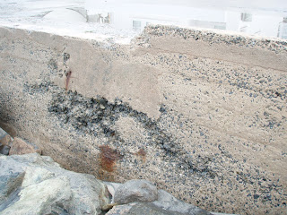
I went on a walk with my camera again. These new photos are only 3 weeks after the first set of photos from my last blog. Frank Quan said that the seawall goes down 30 feet. See in the first two photos that a cave is forming behind the seawall right where it last failed. The horizontal bit of cement you see in the top portion of this photo is the bottom of the road.
The last photo shows the now complete loss of sand from last summer's dredge and beach fill, which was level with the street. Also you can see a hole forming in the seawall. The wall is only as thick as my hand. This hole goes from the tip of my fingers to my knuckles, leaving only 2 inches until it really is a hole. Judging by the previous photos, when that happens, a cave will form behind the wall.
Oceanside does not have a plan in place to address the eroding and dynamic coastline. It is obvious that the rip-rap is no longer doing its job, the initial repair of the failed road is failing, and the seawall is being damaged by the surf. Oceanside's big hope lies in a SANDAG study that is being done that will determine an extensive $50 million sand replenishment project to start in about a year and a half. Until then, they will fill the beach with sand from the dredge the Army Corps of Engineers does every year on the harbor mouth.
I think Oceanside needs some science behind the next beach fill. It seems that just dumping dredged sand on the beach does not help preserve the beach. In fact, without science, how do we know that the problems facing the Strand were not made WORSE by the fill? I also think planned retreat is something that Oceanside needs to start discussing. The homes west of the bluff from Tyson to Wisconsin are on the beach, and soon new measures will need to be enacted to "save" them from the encroaching tide.
Tuesday, January 12, 2010
Oceanside Beaches Losing Sand
The "problem" of losing sand became a problem for homeowners when a storm event in the late 1970's caused part of the Strand to fail near Wisconsin Ave. Rip rap was introduced to protect the area from further failings of manmade structures. Rip rap has a life span of about 30 years and a trip to this area will show just what happens when rip rap has past it's prime.
The stacked rip rap is either settling or being washed away and is noticeably different than it was 6 months previous. When large waves coincide with high tides, the rip rap settles even further. A walk along the Strand tomorrow morning at high tide will show you what I'm talking about. The street and the homes are in the high tide line. This happens every winter, but this winter, the rip rap seems to have given up.
I called the Oceanside Beach and Harbor manager, Frank Quan to learn about Oceanside's long term plan. They have none. Other than more beach fills and a large SANDAG beach replenishment project in the next year and a half, they have no plan about what to do about the encroaching shoreline. The Army Corps of Engineers will dredge the harbor mouth next April, like they do every year, and that sand will be placed on the beach like it was last year. The City is hoping it will last until SANDAG has funding to add more sand.
How long until the City of Oceanside realizes that something has to be done about houses and roads built on the dynamic beach? How long will they continue to issue building permits west of the bluff? I think its time that the City of Oceanside addresses the obvious issue and starts talking about planned retreat or surrender.
Oceanside Coastal Erosion Photos, by Andrea Holeman
Helpful Background Information
http://www.surfridersd.org/documents/DynamicsofBeachSand2007.pdf
MEMORANDUM OF UNDERSTANDING between THE SURFRIDER FOUNDATION, SAN DIEGO CHAPTER and CALBEACH ADVOCATES on MATTERS OF MUTUAL CONCERN REGARDING BEACH PRESERVATION IN SOLANA BEACH, CALIFORNIA (legal document)
http://www.surfridersd.org/documents/calbeach_surfrider_resolution.doc
Surfrider San Diego Chapter Meeting, Jan. 2009. Topic: Beach Preservation (video)
http://video.google.com/videoplay?docid=8831868840769893617&hl=en#